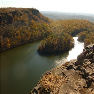
Connecticut is divided into four geographic regions, the Western and Eastern Highlands on their respective sides of the state are separated by the Central Lowlands in the middle, all seeming to rest on the Coastal Slope, a long, narrow stretch along Connecticut’s shore line. A shaded relief map showing these land forms is accessible by clicking here (see also a sketch of the regions by scrolling down the web page).
By their proximity, the Western Highlands, an extension of the Green Mountains, are the most accessible to hikers from the New York/New Jersey region. Elevations in the Western Highlands range from 200 feet in the south to more than 2,000 feet in the northwest. The highest peak in Connecticut is 2,380 feet on Mt. Fissell, near the Massachusetts border.
As interest has grown in parks, trails, and hikes outside the long-standing NYNJ Trail Conference Walk Book regions, we are just beginning to develop content for Connecticut to guide web site visitors. Below are a few resources:
- The Connecticut Forest and Parks Association maintains over 825 miles of its Blue-Blazed Hiking Trails System throughout Connecticut. Maps and detailed information are available on their website.
- A principal source for information for hikers is the Connecticut Department of Energy and Environmental Protection. Its web site includes a list and descriptions of state parks and forests, a map of the state pinpointing parks, and links to trail maps.
- Also helpful is a list of “Official Connecticut Greenways” by year of designation together with a map showing locations. The map includes the Metacomet Ridge System and the Blue-Blazed Hiking Trails.
- BerkshireHiking.Com publishes descriptions of hikes in Connecticut, including those nearby in Western Connecticut.
Click to find descriptions of Connecticut parks and hikes, for either web page sort on the “State” column. There are several wonderful hikes in the Southern Taconics that span Massachusetts, Connecticut, and New York [alphabetized as MA/CT/NY].

